Mexico, Southern Cal and Google Earth
My brother called on the phone last night for one of his seeing how you're doing calls. I actually had the presence of mind to ask him if he remembered where we lived in Mexico as kids. He surprised me by saying Mexico City.
I'd mentioned in some comments earlier on that I'd thought we lived on the outskirts of Mexico City and, some time ago, I thought he said we didn't. I guess I misunderstood him as he said exactly what I'd always thought; That we'd lived just outside of Mexico City. He couldn't remember the exact name of the town, though.
I was ahead of him on one thing: I remembered our street address, 170 Sierra Guaderamma (I thought there was only one m in the street name, not two). He said if I could figure out what the name of the town was to let him know.
I tried doing a search of just the street address last night and came up empty. This morning I started again with renewed energy except I didn't bother with doing a web search. It suddenly struck me I should try Google Earth.
What a "trip" that was. I've had Google Earth on this computer ever since the North Coast Journal said they'd be using it in conjunction with their web site but I hadn't done much with it except find a few houses around town, including my own.
So I went to Mexico City. First time I'd been there in probably 40 years. I was lost. Tried typing in the street address and got nothing. That city is so big I didn't know where to start looking. I gave up.
Then I started thinking about other places. Checked out Acapulco. Yep, you can even see the beach at Las Roquetas(sic?). That's an island just offshore of Acapulco we used to take a glass bottom boat to.
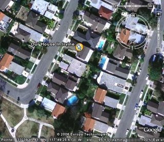
Then I decided to see if I could take a look at my old stomping grounds of Tustin and Irvine in Southern CA. I couldn't remember the street address of our house on Butler Street in Irvine but it was near what I felt should be some recognizeable landmarks so it should be fairly easy to find my way to our old house.
A bit confusing at first as the area has been heavily developed, but it didn't take me too long to find it. Here it is:

Wow. That's kind of neat. Even moved the picture around and found University High School. I went there for most of my high school time.
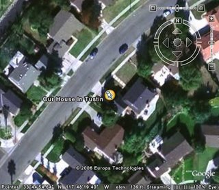
So what about Tustin. For some reason I still remember the street address: 12812 Charloma Drive.
I zoomed in to get a wide view of the Tustin area, centering the picture where my best guess of the location of my house. Then, I typed in the street address in the search field. I guess I was wrong as the image shifted to the upper right and then zoomed in.

Boy, that kinda looks like the house, but not quite. Of course, it's been 35 years or more since I've lived there and even when I lived there I'd never seen it from above.
I started looking around to see any recognizable landmarks and, yep, everything else seems to be in the right place. That's our old house. The thing that really convinced me was the houses behind us then were on a cul- de- sac and there was a cul- de- sac there.
Moving up the street I could also see what used to be Sycamore Elementary School. That was where I went to school. Looks like the playground is still there but hard to say if it's still a school.
Next I tried to find my favorite beach. It was called Scotchman's Cove back then. A few years ago I spoke with a guy that lived right near there and he'd never heard of it, so it must be named something different now.
I knew it was just north of Laguna Beach so, after comparing a few areas, I found it. To confirm, since much of the beach area looked the same, I used the "ruler" Google provides. You can start at one point, draw a line to another point, and it tells you the distance.
I drew a line from what I thought would have been the old Irvine Company private beach to Scotchman's Cove. It was about two tenths of a mile. That's about right.
Since you had to pay to enter Scotchman's Cove at the entrance on Pacific Coast Highway, we used to enter at the Irvine Co. private beach (we had the key) and walk just a ways down the beach to Scotchman's Cove.
Ahhh...the memories. That was fun stuff. I'll have to play around with Google Earth more often. If you haven't already downloaded Google Earth, it's a free download here. Try checking out your old stomping grounds.


16 Comments:
Lived in Mexico did ya Fred?... Getting social security Fred?...
How long you been in the states Fred?...
Any warrants we should no about back in Mexico Fred?...
Any family, children, relatives, past business associates still in Mexico Fred?...
How'd you make it across the border Fred?...
Is your wife an American citizen Fred?....
Did you know that about her before you married her Fred?...
Mind if I make a few calls Fred?...
Or should I say El Senor Fredito?
I'm still playing around with it. Thanks for the reminder about the pyramids. I thought they were closer to Mexico City.
If you want to find them with Google Earth, type in "Teotihuacan, Mexico" into that search field in the Earth sidebar. It was a bit of a challenge for me to find all the pyramids. Some of them look like depressions in the ground, rather than pyramids.
For some local fun, type in Sprowl Creek Road, Garberville, CA and zoom in. You should see a placemark for our very own, Eric Kirk. Hard to see the building as a bunch of placemarks are in the way.
How'd you get your address added to Google Earth, Eric?
10:11 asks, "How long you been in the states Fred?...".
Around 47 or 49 years. Only spent maybe three years in Mexico, but when you're a kid, it seems like a lifetime.
I'll just cut to the chase Fred. Are you now or have you ever been a citizen of Mexico?
Su illegiallo mexicano?
Here's your street, Fred:
Sierra de Guadarrama, in the Barrilaco Hills neighborhood, which is a subsection of Chapultepec.
Your neighborhood was right between two little canyons, and you were just west of Chapultepec Park. The statue you remember was La Angel de la Independencia -- the Angel of Independence -- and it's located smack in the middle of the Paseo de la Reforma, which is one of Mexico City's main thoroughfares. It's the road your parents would have taken if they were driving downtown.
Here's your Google Earth coordinates. One end of the street is here:
19°25'19.86"N, 99°13'32.36"W
... and the other is here:
19°25'35.63"N, 99°13'23.43"W
Am I right?
How the hell do you figure that one out?
The first one might be it, but the marker that shows up on the image doesn't have any building under it. Of course, I lived there something like 45 years ago so much might have changed.
Looks familiar, except I don't remember so much vegetation. Oh, and yes, that's the statue; La Angel de la Independencia.
I'll e-mail this info to the bro and see if your description and the picture rings any bells.
Thanks.
dont stop Fred! Check out reykjavik Iceland, Canberra Australia, the nuclear test sites just north of Las Vegas, Chernobyl, Hollywood Hills, Camp David, Disneyworld, Afghanistan... the thing is endlessly fascinating.
I know. I've been doing all kinds of tours. For one, I was always wondering how far I walked to school when I was in junior high school (C.E. Utt J.C. in Tustin). I figured it was probably a couple miles, one way, but wasn't sure since things seem larger and distances longer when you're a little kid.
Measured the straight line distance using the "ruler" and it showed it just a hair under a mile. Comparing that to the actual route I took, I figured it probably was close to a couple miles. Pretty neat.
Now I can say with certainty to the young kids complaining about bus rides to school being a hassle..." Sonny, when I was your age I walked two miles to school in the snow and rain... and that was just one way...".
I'm just waiting for the opportunity.
How the hell do you figure that one out?
My intense love of Mexico City, plus my insane Google mojo, which is second only to that of Anon.R.mous.
There's not supposed to be any buildings underneath those markers -- they're just the endpoints of that street. I couldn't figure which end would be closer to #170.
Ok. I figured that out after looking and reading your post closer.
That first one seems familiar, though. If you look up from the mark, there's what seem to be some business type buildings. Seems to me, if those are what I think they are, they're at the bottom of what seemed like a pretty steep hill to me at the time.
I sent the info to the bro. We'll see if he remembers better than I.
Hank Sims wins: Here's John's comments. I guess Hank might be right:
The Irvine house looks right (location of park/streets) to me. Tustin
could be right, but it looks like the house has 2 stories (could well have
happened). Sierra Guadarama would have been my guess (for spelling --
with 1 or 2 r's), but your friend could well be right. (I see no pictures of that sight though. So I can't say if it looks familiar. I have a VERY rudimentary layout of streets and a barranca in my mind right by the house.)
I did not think we were that close to Chapultepec (Park, anyway) or the
angel -- though we did see them regularly. (Memory says we "traveled"
though not very long, to get either place. But I'm finding memory is
sometimes wrong ...) I do think we passed the angel regularly when we
went downtown, so that at least agrees with what he says. My best guess,
without seeing any pictures, is that he's right ...
Did I ever tell you about the time I reunited a techno DJ from Brighton, England, with his long-lost father, a colonel in the Nigerian Air Force? All from my computer in Arcata.
Few things give me greater joy.
Well Hank, I guess we know why your such a great journalist now. Nothing escapes you and your home computer.
It helps, sure.
Ok Fred....
Here is a trip for you.
My Dad grew up on Charloma street as well! My Aunt also went to University High School while living on that street. At the time it was called the San Juaqin high school district. It was later broken up into 3 districts.
I've visted the street one or twice with my Aunt and Uncle. I know that Charloma is cut up into a couple different cul-de-sacs though. I know that I couldn't place it exactly but I'm sure I could get the address.
My Aunt Joann Christensen (Also a Uni High School Grad) kept a horse towards the end of the street. The family attended a Catholic Church which was right around the corner. One of the houses on Charloma was home to a group of nuns.
There were 5 kids in the family
Michael, Tom, Nancy, Joanne, and Steve in that order.... let me know if any of this rings a bell. Their parents were Cmr. William and Irma Christensen.
Seems to me I remember someone with a horse or two up at the end of the street. Don't remember the Christiansens. Then again I probably don't remember a lot of the names from back then.
I don't recall a Catholic church near Charloma, but there was St Paul's Episcopal Church down about half a block from my house and around the corner. Across from that was some other church, but I don't recall it being Catholic. It might have been mormon.
I used to have to go to St. Paul's every Sunday with mom and the rest, at least until she realized it wasn't doing me any good. I was actually in the boys choir at that church for a while, believe it or not.
Post a Comment
<< Home